


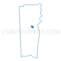
Little Welcome Baptist Church, Mobile County, Alabama
About
Outline

Summary
| Unique Area Identifier | 522616 |
| Name | Little Welcome Baptist Church |
| County | Mobile County |
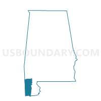
| State | Alabama |
| Area (square miles) | 6.67 |
| Land Area (square miles) | 6.64 |
| Water Area (square miles) | 0.03 |
| % of Land Area | 99.53 |
| % of Water Area | 0.47 |
| Latitude of the Internal Point | 30.73702530 |
| Longtitude of the Internal Point | -88.13921490 |
Maps

Graphs
Select a template below for downloading or customizing gragh for Little Welcome Baptist Church, Mobile County, Alabama


Neighbors
Neighoring Voting District (by Name) Neighboring Voting District on the Map
- Azalea City Church of Christ, Mobile County, AL
- Indian Springs Baptist Church, Mobile County, AL
- Indian Springs Elementary School, Mobile County, AL
- Joseph Dotch Comm. Center, Mobile County, AL
- Moffett Road Assembly of God, Mobile County, AL
- Mt. Sinai Missionary Baptist Church, Mobile County, AL
- Sage Avenue Baptist Church, Mobile County, AL
- St Ignatious Catholic Church, Mobile County, AL
- St. John United Methodist Church, Mobile County, AL
Top 10 Neighboring County Subdivision (by Population) Neighboring County Subdivision on the Map
Top 10 Neighboring Place (by Population) Neighboring Place on the Map
Top 10 Neighboring Unified School District (by Population) Neighboring Unified School District on the Map
Top 10 Neighboring State Legislative District Lower Chamber (by Population) Neighboring State Legislative District Lower Chamber on the Map
- State House District 101, AL (42,749)
- State House District 99, AL (39,791)
- State House District 98, AL (37,831)
Top 10 Neighboring State Legislative District Upper Chamber (by Population) Neighboring State Legislative District Upper Chamber on the Map
Top 10 Neighboring 111th Congressional District (by Population) Neighboring 111th Congressional District on the Map
Top 10 Neighboring Census Tract (by Population) Neighboring Census Tract on the Map
- Census Tract 34.07, Mobile County, AL (7,135)
- Census Tract 61.03, Mobile County, AL (5,080)
- Census Tract 33.02, Mobile County, AL (4,674)
- Census Tract 34.08, Mobile County, AL (3,994)
- Census Tract 34.02, Mobile County, AL (3,693)
- Census Tract 35.01, Mobile County, AL (3,664)
- Census Tract 49, Mobile County, AL (3,289)
- Census Tract 61.02, Mobile County, AL (2,941)
- Census Tract 34.06, Mobile County, AL (2,791)
- Census Tract 26, Mobile County, AL (2,682)
Top 10 Neighboring 5-Digit ZIP Code Tabulation Area (by Population) Neighboring 5-Digit ZIP Code Tabulation Area on the Map
- 36608, AL (36,864)
- 36618, AL (16,737)
- 36617, AL (13,967)
- 36613, AL (12,749)
- 36607, AL (6,852)
- 36612, AL (4,541)